River restoration contributes to flood risk management by supporting the natural capacity of rivers to retain water. As flood risk consists of damage times occurence, flood risk management needs to reduce either the damage, or the likelihood of floods to occur, or both. River restoration reduces the likelihood of high water levels, and improves the natural functions of the river at same time.
Classic flood risk management
In a natural river system a river spreads water beyond its banks and over extended areas of a floodplain during periods of high water. In order to protect property and contain waters, the classic flood risk management approach is to constrain watercourses. This is commonly done by building dykes and straightening rivers to increase discharge capacity, dredging to deepen channels, and building reservoirs and artificial retention areas to store excess waters.
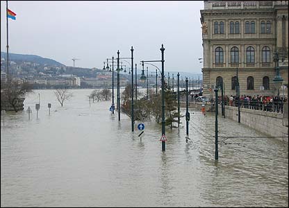
While this generally reduces the likelihood of flooding, in the event of extremely high waters it increases the amount of damage if the engineered system is overwhelmed or fails. Without natural features such as wetlands and meanders, excess waters cannot be absorbed. Any breach will release an enormous amount of water, with potentially catastrophic consequences. Continuously reinforcing and building higher dykes cannot overcome this weakness, and is a very expensive option. Historically, engineering solutions upstream have created peak flows downstream, leading to more engineering. Moreover, climate change scenarios predict more extreme weather events and higher sea levels. A new approach is needed.
Modern flood risk management
By re-connecting brooks, streams and rivers to floodplains, former meanders and other natural storage areas, and enhancing the quality and capacity of wetlands, river restoration increases natural storage capacity and reduces flood risk. Excess water is stored in a timely and natural manner in areas where values such as attractive landscape and biodiversity are improved and opportunities for recreation can be enhanced. In these ways, river restoration directly contributes to climate change strategies aimed at mitigating the effects of increased and erratic peak flows and droughts.
This approach to flood risk management not only meets objectives of the EU Floods Directive, but also the Water Framework Directive, and the Birds and Habitat Directives.
Managing flood risk in a changing climate
River restoration is increasingly being delivered by flood risk managers to create space for flood water. Reconnecting floodplains to the river and managed realignment in estuaries is an important mechanism of water management.
Future climate change will potentially affect all aspects of the rainfall regime. The precise nature of these changes is uncertain, particularly for those extreme events, whether of short or long-duration, which tend to lead to flooding. Increases in rainfall at all scales will increase the risk of flooding to a greater or lesser extent, depending on how these increases manifest themselves in space and time and of the rainfall-runoff characteristics of the catchment in question.
Some case studies on the RiverWiki that relate to this issue include the Isar Plan, the River Quaggy flood alleviation scheme & Cerný potok stream restoration scheme.